Unlocking the power of Trimble commercial location data to increase efficiency and safety
In today’s competitive market, the ability to effectively use and analyze location data is a crucial component of the quality of service provided by transportation and logistics companies. From planning routes to managing resources, driver safety to customer service, locations are in many ways as important as road and map data. That’s why Trimble has created a database of locations tailored to the needs of our industry.
Rest stops, stores, gas stations, warehouses, distribution facilities, manufacturing sites and more: without a clear view of these places, it can be difficult for carriers, shippers and their teams to do their jobs. In the piece below, we explore what makes for good location data, its impact on operations and how transportation companies can use it to significantly enhance efficiency, reduce costs and deliver better service to customers.
How we make location data more valuable
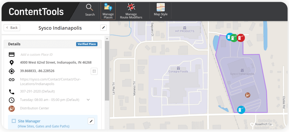
Location data plays a vital role in how fleets operate, especially in the challenging last mile of delivery. Several different elements comprise location data: GPS coordinates, address information, geofences, entry and exit gates, facility details and more. The more data you have, the more complete your picture of a particular location.
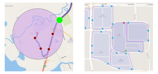
While several of those details are well understood, some are more complex. “Geofences,” for example, are virtual boundaries around specific locations. These are set up by navigation solution providers to denote the geographic space near a particular location and mark the location’s outline with a collection of GPS coordinates.
In consumer mapping applications, geofences are traditionally circular. But the Trimble Geographic Information System (GIS) team goes a step further. The boundary polygons we use in our own solutions can be drawn to any shape, allowing for a precise perimeter around a specific location and we’ve implemented them for millions of locations.
More precise polygonal geofences reflect a location’s true size, geography and road connections. They allow for a clearer picture of how a vehicle can access a location from surrounding roadways, and also make it easier to mark where entry and exit gates are and exact locations associated with an address.
In addition, we enable fleets to customize their location data to include additional details, such as a customer’s contact information, phone number, and custom notes about how best to get the job done in that specific facility. By adding their own details to public commercial places, companies can optimize routes, avoid known hazards, and ensure that drivers have the most accurate and relevant information at their fingertips.

The benefits of improved location data
Our approach to location data and geofences affords transportation companies several advantages, including more precise navigation and exact arrival and departure times, more accurate dwell and detention time insights, safer facility entrances and exits and increased efficiency and productivity.
All of this is made possible through polygonal geofences. First, with a traditional circular geofence around a location, it can be difficult to tell exactly where a vehicle should enter a facility and how to navigate it to find the vehicle’s ultimate destination: the pickup or drop-off spot. This is especially important when distribution center addresses can be tied to front doors instead of vehicle entrances, there can be different receiving and shipping entrances, or there’s a multi-tenant warehouse with numerous delivery options.

But with a polygonal geofence, the driver has a clear view of a facility before they arrive and can be guided to the exact entry point they need to access the location and deliver or pick up their load. They can easily see where entry and exit gates are and where they can park. This helps drivers avoid unnecessarily driving around parking lots looking for where they should be, which in turn helps them stay safe by avoiding collisions with other vehicles also trying to navigate a complex situation.
Second, polygonal geofences make it easy to see exactly where a vehicle is and when it arrived or departed. With a circular geofence arrival and departure alerts can be inaccurate. What if a vehicle is disabled a short distance from a facility, within the circular boundary, but not within the facility itself? Or what if the driver is lost on roadways near the facility and can’t find their way back?
Instead of estimating when a vehicle arrives at or leaves a facility, with a polygonal geofence, fleet managers can get much more accurate information when a vehicle’s GPS signal crosses a boundary. With this information, fleet managers can see in real time how much time is spent in a location, adjust ETAs for subsequent deliveries, and alert customers to any possible changes. This information also helps give greater insight into dwell and detention times, enabling fleet managers to tackle this recurring issue.
Additionally, geofences enable better management of driver behavior, such as reducing unnecessary idling, which in turn can lead to fuel savings and lower emissions.
Gaining a clear picture of every location
Incorporating commercial data, geofences and custom locations into your transportation operations is not just about keeping up with industry trends—it’s about staying ahead. These tools offer insights that empower fleets to navigate any obstacles on the road with greater precision and confidence. As the industry continues to evolve, the companies that utilize these technologies will be the ones that set the standard for the industry as a whole.
Our detailed commercial location data, which includes tens of thousands of verified commercial locations, is incorporated into our portfolio of solutions, like Trimble PC*Miler, CoPilot, Appian and more, and is also available through our developer APIs.